The river feels like an ocean. I can see waves coming at me from all directions through the opening in the cataraft frame between my feet. We’re three days into a nearly 250 mile long high-water sprint down the Salmon River and approaching one of the largest rapids of the trip, Hancock. 65,000 cubic feet per second (CFS) of water is flowing beneath us, we’re riding the peak flows of 2018, the 50th anniversary of the Wild and Scenic River Act.
Marsh Creek
Days earlier our group of five launched on Marsh Creek, a small tributary of the Middle Fork Salmon. Here the river is only about 30 feet wide but presents its own challenges. A trip which departed before us pinned a raft in a log jam, losing the boat and its gear. We pass a red paco pad pinned in a log jam and a sunken raft oar, reminding us of the consequences of high-water boating.
Our catarafts by comparison are fast and nimble, we’re still carrying gear, but more of a backpacker style float. Eric calls these trips “catboat lite,” think bringing whiskey instead of a 30 pack of beer - that would be more “catboat heavy."
We eddy out to scout Dagger Falls. This intimidating rapid drops over two tall bedrock ledges. It’s so steep that the Idaho Fish and Game installed a fish ladder to allow salmon passage. We are after all, descending into one of the last remaining salmon strongholds left in the lower 48 states.
Jon and Eric identify a small, boatable seam through the two drops. Four of us decide to run the rapid, and two to portage. The team shuttles two boats and then we run the rapid, sliding through without incident. With our first major rapid complete we float past the Boundary Creek launch site, the last road access for 115 miles.
The river leads us into the Frank Church River of No Return Wilderness. In 1980, this incredible area, which spans nearly 2.4 million acres, was protected in large part due to the efforts of late Idaho Senator Frank Church.
We’re floating through pristine elk, deer, bighorn sheep, and black bear habitat. In the water beneath us, steelhead and three species of salmon fight their way past dams downstream, an astonishing 900 mile journey to small spawning streams in these protected mountains. The fly fishing is great here too, I once watched in awe as two rare bull trout rose from the depths, giving chase to the trout on my line.
The Wild and Scenic Middle Fork Salmon is no accident. Throughout the early 1900’s a dam building frenzy swept across the United States, impounding tens of thousands of rivers. Conservationists, alarmed at the rapid destruction, worked to draft the Wild and Scenic Rivers Act. The bill, which passed by a wide bipartisan measure on October 2, 1968, created the legal framework to preserve rivers of “outstandingly remarkable scenic, recreational, geologic, fish and wildlife, historic, cultural or other similar values” in free-flowing condition “for the benefit and enjoyment of present and future generations.”
And enjoy the Middle Fork we have. Each year upwards of 10,000 lucky visitors journey down the river, which is carefully permitted to protect the fragile corridor. We stop to pick up ours at Indian Creek Guard Station, taking a moment to admire the newly rebuilt boat ramp down to the river. A few years back Zach and Eric led a team of volunteers who rebuilt the 100 foot long ramp by hand.
The miles fly by as we ride peak flows of 6.5 feet on the river gauge. A massive wave marks the entrance of Ouzel Rapid, which at most flows is a mere riffle. Spencer hits the wave to the left, Jon to the right, and I aim center, realizing my mistake as the wave crashes down upon me. The boat flips, launching me into the chilly torrent of spring runoff.
I climb atop the capsized raft and attempt to balance on one tube, leveraging my weight on a length of webbing attached to the opposite side of the boat. In the chaos a wave smashes into me and I slip, smashing head first into the bottom of a hard plastic drybox. Fortunately, my helmet has absorbed the impact and I stand up for another try, finally reflipping the boat with effort.
On to the Main Salmon
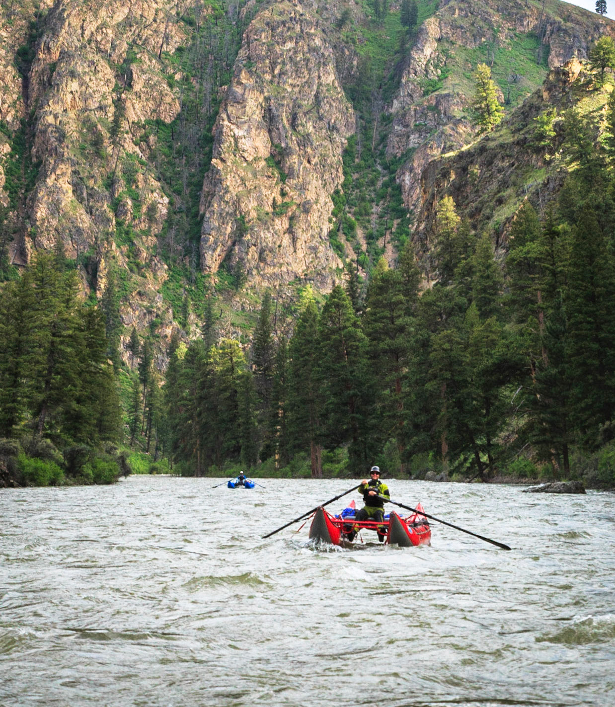
At the mouth of Impassable Canyon, we confluence with the Main Salmon River, and the volume of water beneath us jumps to over 30,000 CFS. At times we drop oars, staring down at the boils and current lines swirling beneath our feet. I recognize the now-flooded campsites we’ve used on previous trips now being cleansed by the rivers power.
Each creek we pass is flooding; the Main will double in volume by the end of our trip. Hancock Rapid looms, and I watch Elizabeth expertly thread the series of giant crashing waves ahead. I’m not so lucky, without warning a rogue wave rears up and knocks me into the river for my second swim of the trip.
Between rapids we look up the blossoming canyon, floating past golden arrowleaf balsamroot and white serviceberry flowers. A bright red and iridescent green flash catches my eye, lewis’s woodpeckers, are alighting on snags along the river banks. The river is a refuge for this rare species, which has likely declined by as much as 50% since the 1960’s.
Our oars brace against the massive waves of Chittam, Vinegar and House rapids, the latter named for a massive boulder now submerged beneath the rivers turbulent flow. Four of us make it through. I look back just in time to see Jon’s 16’ cataraft pirouette before crashing upside down in the third wave. Jon skillfully rights his boat as we float towards the final whitewater of the journey.
Now at 65,000 CFS, our boats disappear between the waves of Ruby and Lake Creek Rapids, bobbing along like pool toys in an ocean. The river widens and calms as we approach the town of Riggins, four days and 250 miles from our launch site high in the Idaho Wilderness.
What’s Going to Happen?
We’re lucky to have rivers like the Middle Fork and Main Salmon protected. I can’t help but think the words, “What’s going to happen?” played in the heads of Senator Frank-Church and other conservationists as they fought to protect the last wild rivers and wild places in the US.
Other rivers haven’t been so lucky, the Lower North Fork Clearwater canyon now sits buried beneath Dworshak Dam, one of the largest dams in the region. The South Fork of the Clearwater runs with a perpetual copper color from the historic mine tailings it passes through.
It’s easy to forget the toils of these past conservationists and simply enjoy the fruits of their labors, but now more than ever we have our own struggles to face. In 2018, the South Fork of the Salmon made the Most Endangered Rivers List by American Rivers. A mine proposed by Midas Gold could contaminate the clear-flowing class V river, threatening critical spawning habitat for wild endangered salmon, steelhead and bull trout.
With its more challenging rapids, the South Fork hasn’t received the same attention of the Middle Fork or Main, but it’s no less special. It’s eligible for Wild and Scenic River Status, but the mine could change all that, clogging the river with sediment and toxic runoff. Is the free-flowing South Fork more valuable than gold? I wonder, what’s going to happen next…